


Le Taillefer

orsel
User GUIDE
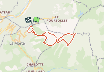

Length
15.9 km

Max alt
2851 m

Uphill gradient
1224 m
Km-Effort
32 km

Min alt
1690 m

Downhill gradient
1219 m
Boucle
Yes
Creation date :
2025-06-17 05:14:12.062
Updated on :
2025-06-17 17:23:54.566
9h08
Difficulty : Very difficult

FREE GPS app for hiking
 SityTrail
IGN / Geographical institutes
SityTrail Plus
The world is yours!
About
Trail Walking of 15.9 km to be discovered at Auvergne-Rhône-Alpes, Isère, La Morte. This trail is proposed by orsel.
Description
quelques passages un peu scabreux
Positioning
Country:
France
Region :
Auvergne-Rhône-Alpes
Department/Province :
Isère
Municipality :
La Morte
Location:
Unknown
Start:(Dec)
Start:(UTM)
726205 ; 4992068 (31T) N.
Comments